


The utilities sector has experienced rapid growth due to technological advancements and is expected to continue growing until 2023. However, as the global macroeconomic climate evolves, providing clean, safe, affordable, and consistent power may become increasingly challenging. Industry leaders must be adequately prepared to address these challenges to maintain the sector’s growth.
While extreme weather, cybersecurity risks, the expansion of variable renewables, and supply chain bottlenecks may continue to pressure grid stability, inflation, and high fuel prices, these factors may keep power prices high. Opportunities in 2023 may be ripe thanks to new technology and encouraging regulations, which will also aid the industry in its objectives.
Grid flexibility is expected to evolve and expand next year, overcoming the supply chain snags. Battery storage is predicted to advance more quickly in the US in 2023 as the share of renewable energy in energy production rises, extreme weather events become more frequent, and new legislation strengthens the storage’s value proposition. The newly appointed utility executives are also primarily technology leaders. The future value propositions will revolve around developing strategies that will be determined as much by technical capabilities as by commercial strategy.
LiDAR and its Deployment in The Power Utilities Industry
As a method of distant sensing, Light Detection and Ranging technology (LiDAR) offers several benefits. The capacity of users to resample regions swiftly and effectively is one of them, as are high accuracy, high point density, vast coverage areas, and user-friendly interfaces. This makes it possible to quickly produce findings, cover enormous regions consistently and correctly, and map discrete changes at a very high resolution. One of the main benefits of LiDAR data is its unparalleled accuracy and reliability. LiDAR is a precise, economical means for gathering pole information over substantial electricity distribution regions. Determining the necessary degree of data accuracy and recording the level attained is crucial for data collection and later utilization. For effective and widespread usage and to optimize the data’s usefulness, it is critical to document data correctness.
Leveraging LiDAR for the Most Accurate and Reliable Results
The following transmission and distribution line components must undergo routine, thorough examination by electrical utilities. Due to the nature of how power lines are constructed, power line inspections will always bring up unique difficulties. They frequently travel across various terrains and landscapes to link producers and users in the quickest amount of time feasible to prevent power losses on the route.
In August 2016, The Offshore Renewable Energy Catapult (ORE), in collaboration with Centrica, successfully ran an in-field LiDAR measurement campaign. To evaluate the effects of erosion on performance, testing used LiDAR technology to precisely measure the power performance before and after blade repairs were finished. According to the testing, mild wind turbine blade erosion might be repaired to raise yearly energy output from 1.5% to 2%. The findings offer owners a means to weigh the cost vs. value when making repairs and upkeep decisions. The repeatability of LiDAR specs is gauged by precision. Repeated measurements of the same target with high accuracy will be extremely near the mean value, whereas measurements with low precision will have a wide range of values around the mean. These precise data sets and points help the utility maintenance workforce deliver results in less time than traditional pole assessment methods.
Techwave provided a comprehensive solution for bushfire mitigation, including surveys and inspections of assets in bushfire-prone areas. The resulting data allowed for proactive risk reduction by identifying vegetation encroachment and hardware defects. The data analytics services were crucial for electrical networks in hazardous bushfire risk areas, and Techwave delivered by updating spatial information and performing vegetation clearance analysis.
Multi-faceted Functionalities of LiDAR in Utility
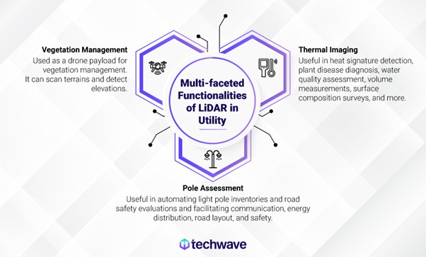
Thermal Imaging – LiDAR, thermal imaging sensors, and other sensors attain unmatched precision when used on drones. This precision is essential for creating accurate maps and models that, when used by machine intelligence, may detect heat signatures, diagnose plant diseases, evaluate water quality, provide volume measurements, analyze surface composition surveys, and more.
Pole Assessment – LiDAR can help transportation authorities automate road safety assessments and light pole inventory. Previous research focused on locating and mapping lighting poles in urban contexts using short, generally level highway segments, despite modest advances in extracting light poles using mobile LiDAR data. Roadside utility poles are crucial for communication, energy distribution, road layout, and safety.
Vegetation Management – Companies may save up to 20% of their annual expenditure for vegetation control by utilizing satellite data. Now that LiDAR has become sufficiently tiny, it is simple to employ it as a drone payload for vegetation management services.
What the Future holds in Store for LiDAR in the Utility Sector and other Markets

The LiDAR Global Market Report 2022 is surveyed by The Business Research Company. Given that it covers 60 different geographic areas, it is the most thorough report on the subject currently accessible. The size of the worldwide LiDAR market is anticipated to increase at a compound annual growth rate (CAGR) of 18.68%, from $1.49 billion in 2021 to $1.77 billion in 2022. At a CAGR of 19.49%, the size of the worldwide LiDAR market is expected to increase to $3.61 billion in 2026. By using LiDAR systems in various applications and welcoming big international technology development businesses to the market, North America’s market is anticipated to control a sizeable portion of the worldwide market. LiDAR has several chances to expand its utilization through numerous applications. This technology will advance further to fulfill the demands of industry experts everywhere. Ultimately, it is becoming increasingly evident that different LiDAR technologies are convergent, and LiDAR & imaging technologies work together.